This story is the fourth part of the Martimoaapa history series. The series recounts the history of Martimoaapa and its surrounding area from ancient times to the present day, highlighting signs and memories that are still visible to travelers in the terrain, serving as reminders of times past.
The phases of Finland’s independence and wartime years also touched the Martimoaapa area. Jäger soldiers traversed a secret route through the area to Germany, and the Simo skirmish took place in the neighboring Maaninkajärvi. During the Lapland War, a bomber made an emergency landing in Sarkakangas, from where a badly wounded observer hiked through the marshes and forests of Martimoaapa. After the wars, Ala-Penikka Hill provided a location for the Lapland Air Command’s radar station.
Via the etappe routes to Germany for Jäger training
In 1809, Finland was annexed into the Russian Empire, but Finland was allowed to retain its own laws and administration. However, in 1899, Russian Tsar Nicholas II signed the February Manifesto, which aimed to Russify Finland and restrict its autonomy. In university circles, the Jäger Movement emerged, with the goal of forming a Finnish national army and separating Finland from Russia. Since the Finnish army had been disbanded in 1905, the independence movement sought cooperation with Germany, where men could secretly be sent to receive military training.
To Germany, specifically to the Locstedt camp as part of the Jäger Battalion, several hundred men were initially sent for training, but then Germany increased the number to 2000. Organizing such a large number of men covertly across the border required coordination. From Lockstedt, Jägers were sent back to Finland to organize recruitment and logistical operations, thus creating an organized logistics network. A total of 52 staging points were established on the Finnish and Swedish sides to assist the Jäger candidates, as those aspiring to become Jägers were then called, and Jägers in moving between Finland and Germany. The staging routes ran through Lapland and Northern Ostrobothnia to Sweden.
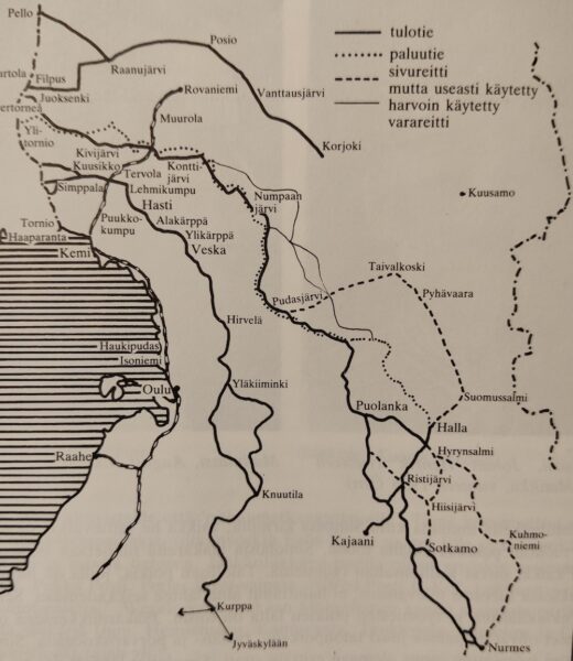
The Kemi staging point was established in September 1915 and was shut down in June 1916 after being exposed. Through the Kemi staging point, around a thousand men traveled to Germany, and through the Tornio staging point, a couple of hundred did. After the exposure of the Kemi staging point, the Jägers were directed to travel through the inland areas of Peräpohjola, including the Tervola and Muurola staging points.
Many people from Kemi were involved in various roles in the staging operations, and many residents of Simo and Tervola also supported the staging operations. For example, the Ylikärppä and Hast farms in Simo and the Kumpula farm in Tervola acted as so-called staging houses, offering shelter to travelers along the staging routes. The Hast farm meadow-sauna and the meadow-sauna in Maaninkajärvi were also important resting and meeting places along the staging route.
At that time, Kemi had about 2,500 residents, in addition to a border guard consisting of a few hundred Russian soldiers. Jäger activities were closely monitored by various informants. It took quite a bit of ingenuity to run staging operations under the watchful eyes of these surveillance efforts. Additionally, a police detachment of four men roamed around the parishes interrogating and inspecting locals.
The escape of Arvi Hällfors
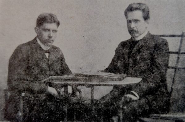
Arvi Hällfors was one of the significant figures in the operation of the Kemi staging point. Hällfors was born in Oulu in 1888 and lived in Kemi with his mother and sister around the beginning of the First World War. He had been asked to write the municipal history of the city of Kemi.
One autumn day in 1915, he was invited to participate in the Jäger staging activities. He became one of the key figures in organizing the Kemi staging point. He persuaded, among others, the chief of the Kemi police department, Linderoos, to join the secret project and recruited people from as far as Rovaniemi to participate in the staging operations.
After the exposure of the Kemi staging point, Hällfors traveled to Hailuoto, where he had acquaintances at the Hailuoto rectory. In Hailuoto, he hid from the authorities. Occasionally, news of friends being caught and escaping across the border reached Hailuoto. and finally, on Sunday, September 24, 1916, he received a message at the rectory informing him that a warrant for his arrest had been issued.
Upon hearing about the arrest warrant, he packed his belongings, took his shotgun and backpack, and set out on the escape journey. He posed as a hunter and first traveled to Haukipudas, from where he continued north along the riverbanks, sometimes by horse-drawn carriage and sometimes on foot. He crossed the Kuivasjoki river with a boat he had taken without permission and traveled through the remote areas of the Simo River to Maaninkajärvi niittysauna in Simo. There, he rested and gathered his strength because the challenging trek through the wilderness was just beginning.
The wilderness between the Simo and Kemijoki rivers lay ahead. He traveled from Maaninkajärvi to Ylikärppä and began his journey through the wilderness. Along the way, he got lost a couple of times and fell into Mikko-oja, soaking his clothes. After trekking through the wilderness for almost a month, he finally arrived in the village of Tervola. After drying his clothes and repairing his shoes, he set out on the final leg of the journey towards Tornio. After nearly a month-long escape journey, he finally crossed the border into Sweden on October 3rd.
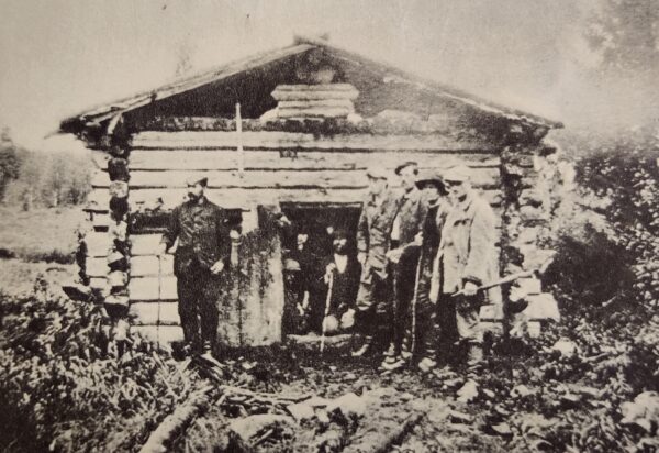
Kivalo’s Jägers Hut
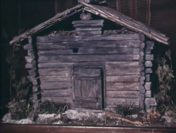
As mentioned earlier, one of the support bases of the Kemi staging point, Hasti’s farmhouse sauna, was located on the edge of Penikanjänkä. Both the Hast farm and the meadow-sauna were stopping points for the Jäger candidates and Jägers who had traveled a long distance to rest on their secret journey. The meadow-sauna also served as a hiding place for Jägers who had survived the skirmish in Simon.
There is no information about the original construction of the field sauna, but it was renovated in 1939 by the Civil Guard (Suojeluskunta). During the renovation, reindeer herders were asked about the origin of the field sauna, and they speculated that it had originally been a forest sauna built by the state.
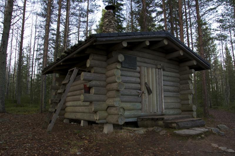
The original Jäger lodge was reconstructed in the 1970s by the Forestry Administration of Kemi Management Area and the Kemi Reserve Officers’ Association (Kemin reserviupseerit ry), but the lodge from that time has already been dismantled. In 1994, the Länsi-Pohjan section of the Jäger Battalion 27 Heritage Association (Jääkäripataljoona 27:n perinneyhdistys), the municipality of Keminmaa, and the Forestry Administration (Metsähallitus) built a new Jäger hut. The inauguration ceremony for the new lodge was held on September 7, 1994. There is a memorial plaque on the wall of the Jäger hut with the inscription: “Etappikämppä 1915-1917”. Nowadays, Kivalo’s Jäger hut serves as a day hut on a hiking trail.
The Simo skirmish
An armed conflict broke out between the Jägers and the authorities at Simon Maaninkajärvi. This battle marked the first open conflict on Finnish soil between Finns and Russians since the war of 1808-1809. The events of December 11, 1916, at Maaninkajärvi’s field sauna became known as the Simo skirmish (Simon kahakka) and were recorded in history books.
A group of seven Jägers were occupying the northern staging point and had come to Maaninkajärvi’s meadow-sauna to stop for a moment, but they decided to stay and wait for better skiing conditions. The weather was mild, the snow soft, and the ground slippery.
Based on the tip-off, the authorities arrived at Maaninkajärvi’s meadow-sauna. Jäger Vainio noticed the newcomers and sounded the alarm. The authorities surrounded the lodge. All eight Jägers were stuck inside the cabin. Despite having weapons, their situation was dire; they were in a flimsy cabin where bullets could easily penetrate the walls, and the entire cabin could be set on fire.
The Jägers had decided to fight to the end, and surrender was out of the question. They decided to charge out together. Bullets rained down from both sides. In the heat of the skirmish, one of the Jägers was killed, and one was seriously injured. The last Jäger remaining in the cabin was smoked out by setting skis on fire next to the cabin wall. Three of the Jägers were captured, and four managed to escape.
The escaped Jägers hiked 65 kilometers through the wilderness of Martimoaapa towards Puukkokumpu and Hastin talo. A 40-man military unit was dispatched after them, interrogating locals with force. The fleeing Jägers arrived at Hastin talo, rested for a moment, and then moved to Hasti’s meadow-sauna. There, they joined a few other unit members and stayed at the sauna, resting for a few days.
The military unit never caught the fleeing Jägers. They continued their journey across the fells to the border and then to safety on the Swedish side.
There were 16 Jägers trained in Tervola, which was a significant number considering the village’s population. Although there were only a few locals at the Jäger training camp, Simon became an important location for the entire Jäger movement due to the events of the Simon skirmish.
The first Jäger monument in Finland was erected by the Civil Guards (Suojeluskunta) at Maaninkajärvi in memory of the Simon skirmish in 1927. Next to the monument stands a replica of the old Jäger cabin, as the original Maaninkajärvi niittysauna burned down in 1946. The area of the Jäger cabin was protected in 1957. The inscription on the monument reads: “On this spot, the Jägers fought for the first time on our own land for the freedom of our country against the Russians on 11.XII.1916. In the skirmish, Jäger volunteer A.W. Lyytikäinen fell.”
In Simo, the Jäger Route (Jääkärireitti) was renovated in 2019 to honor the memory of the Jägers. The Jäger Route runs from Kuivaniemi’s Veska to Ylikärppä’s Hanska via Maaninkajärvi Jäger Cabin, spanning a length of 16 kilometers. Various organizations, mainly reservists, renovated the trail through volunteer work. The trail features 27 wooden bridges and numerous signposts. The route follows the original etappireitti as closely as possible.
In Lehmikumpu, Tervola, there is also a memorial for the Kumpulan Jäger Etappitalo (Jäger Rest House) associated with the etappireitti. The memorial was unveiled on June 19, 1994, and was implemented by the Länsi-Pohjan section of the Jäger Battalion 27 Heritage Association (Jääkäripataljoona 27:n perinneyhdistys). Memorial plaques for Jäger Rest Houses can also be found on the walls of other nearby village houses.
Emergency landing of a bomber
The Lapland War was fought between 1944-1945 between Finland and Germany, when after the end of the Continuation War, Finns had to expel the Germans from Finland. The eviction escalated into a war, mostly fought in the Lapland region. The army infantry and jäger battalions were supported by the air force. The air force base was located in Rissala, Kuopio, and Kemi. The planes operated mostly towards Ranua and Rovaniemi, as well as Kittilä, Muonio, and Käsivarsi.
On October 10, 1944, Bomber Squadron 44 at Rissala airfield received orders to bomb the German supply convoys retreating between Ranua and Rovaniemi. One of the squadron’s planes was returning from the direction of Ranua when it came under fire from German fighters and had to make an emergency landing in Sarkakangas, Simon. Sarkakangas is located about 20 km northeast of the Martimoaapa area. The plane first slid across the open marshland and then crashed through about sixty meters of thick forest. The plane was completely destroyed and caught fire.
The plane had a crew of four, of which only one survived the emergency landing. The observer, Second Lieutenant Aarne Keko, managed to escape from the burning plane, although badly burned. Keko, wounded, began to hike away from the enemy, southwest through the wilderness and marshes of Martimoaapa, using a compass.
Keko’s painful journey lasted almost 35 kilometers, and it took nearly a week before he reached the vicinity of human habitation in Pömiö. As he passed through Pömiö, Keko began to hear the sounds of children playing. Following these cheerful sounds, Keko arrived at the yard of the Ylipää school, where the students and teachers received the bloody and sooty man with wonder.
The idea of erecting a memorial at the site of the plane crash arose from the members of the Arpeen Erä hunting club who were moving in the Sarkakangas terrain in 1969. Thus, a memorial was erected in Sarkakangas through volunteer work, designed by the Kemilä professor Ensio Seppänen. The memorial “Fellow Aviators – The Land is Free” was unveiled on October 10, 1970. The memorial bears the names of the fallen heroes in the emergency landing and three steel crosses. Later, after Keko’s passing, a fourth cross was added to the memorial. Lapland Air Command’s official memorial ceremony is held at the site annually.
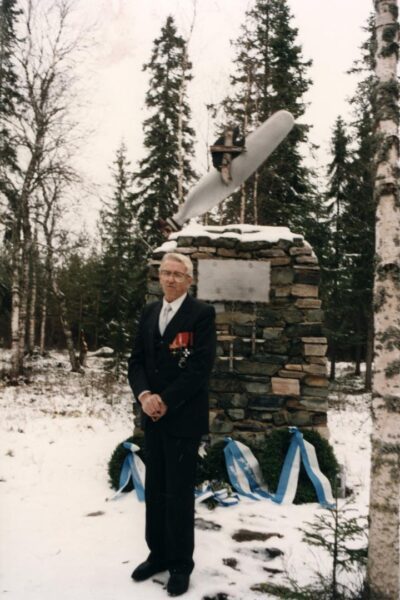
As a side note, it should be mentioned that first, sculptor Ensio Seppänen’s 100th birthday anniversary will be celebrated this fall, marking a special year for him. Seppänen’s sculptures can be found all around the Sea Lapland region, and visitors can explore them through various guided tours. More information about these tours can be obtained from local tourism guides in Sea Lapland. Secondly, on the outskirts of Simon Länsimaa peat production area, south of the Martimoaapa protected area, there is also a memorial related to the wartime years; a burial site for Russian prisoners of war from the Continuation War era. During the Continuation War and the Lapland War, large prison camps operated in Kemi and Oulu. Prisoners were sent from these camps to work on road and power plant construction, logging sites, and as the war continued, even to farms to supplement the labor shortage when the men of the household were at the front lines.
Defense Forces radar station
In the early 1900s, Ala-Penikka was a popular skiing and hiking area. At the summit of Ala-Penikka stood a fire watchman’s cabin and a fire observation tower, providing excellent views for monitoring forest fires. After the wars, in 1955, a fixed defense forces radar and air defense station was established at Ala-Penikka.
The radar station included residential and office buildings, as well as storage and a bunker. The area was used for training, shooting exercises, and military construction. The radar monitored the airspace of the surrounding areas, and the information was used to assist in regulating and directing air defense.
Following the establishment of the radar station, the fire watchman’s cabin and tower were moved to Keski-Penikka. As a result, hiking activities shifted mainly from Ala-Penikka to Keski-Penikka. Therefore, Ala-Penikka became unfamiliar to many hikers and travelers, as access to the area was restricted during the radar station’s operation. Unauthorized movement within the defense forces area is prohibited.
Today, fixed air radars have largely been replaced by mobile radar systems, and the Ala-Penikka radar station was closed in 2007. In 2013, a berry picking company purchased the former radar station properties.
Read next: Martimoaapa history part 5
Sources and more info:
- Suomen itsenäisyyden tekijät ja vaiheet, Helsingin Suomalainen Klubi
- Martimoaapa‐Lumiaapa‐Penikat Natura alue, Kulttuuriperintökohteiden inventointi 2007, Metsähallitus
- The National Library of Finland
- Kultuuriympäristön palveluikkuna, The Finnish Heritage Agency
- Martimoaapa history, Nationalparks.fi, Metsähallitus
- Historia tulee polulla vastaan osa 4, Pentti Korpela, Kemi.fi, 2020
- Kemin seutu, document, Veikko Laihanen Oy, Elonet, 1963
- Kunnostettu Jääkäripolku avattiin Simon ja Kuivaniemen välille, Yle, 28.10.2019
- Kolme vuotta talkoita – Maaninkavaaran jääkärireitti avattiin: “Rouva kysyikin kotona, että mitä meinaat alkaa nyt puuhata?”, Lapin kansa, 30.10.2019
- Fateful Flight, the Finnish Virtual Pilots Association website
- Lapin lennoston historia, Puolustusvoimat
- Lapin koulutushistoria: kirkollinen alkuopetus, kansa-, perus- ja oppikoulut, osa 1, Juhani Lassila, 2001
- Entinen tutka-asema muuttui Simossa marjanpoiminnan keskukseksi, Lapin Kansa, 18.09.2016
- Simon kirja, Hannu Heinänen, Mauno Hiltunen, 1986
- Keminmaan historia, Pentti Koivunen, 1997
- Kahen puolen Kemijokea – Tervolan kunnan historia, Eemeli Hakoköngäs, 2017
- Aseveljet I, K. A. Wegelius, 1924
- Routaa ja Rautaa II – Kemin etappi, K. A. Wegelius, 1927
- Suomen Vapaussodan historia, J. O. Hannula, 1934
Translated with ChatGPT
Write a comment